
Satellite Image Analysis using Machine Learning
Machine Learning, or automated learning, enables the identification of patterns in data based on algorithms that classify each factor according to its degree of influence, continuously learning and improving the process.
Artificial Intelligence (AI) focuses on researching a wide range of concepts, such as reasoning, knowledge representation, planning, learning, and language processing, among others; all with the aim of imitating the functions that humans can develop. Artificial Intelligence is a multidisciplinary field that draws on knowledge from computer science, mathematics, engineering, psychology, or even philosophy and linguistics.
Machine learning is a branch of Artificial Intelligence (AI) and, as such, its purpose is oriented towards the development of mechanisms or algorithms that imitate human cognitive functions. For its part, Machine Learning (ML) has gained great relevance and independence in recent decades because, while sharing the use of algorithms to enable computers to learn from data inputs, it has a characteristic educational sense that provides devices with their own autonomy.
Machine Learning excels in detecting and classifying patterns within image recognition, enabling countless uses for the inspection and maintenance of assets and facilities, the discovery and analysis of data patterns generated by supply chains for route optimization and fleet and warehouse management, automation applied to quality inspection in logistics centers, detecting and removing damaged and worn product shipments, or supporting decision-making for the location, classification, and management of logistics centers.
The discovery of new data patterns has the potential to revolutionize any business
Algorithms used by Machine Learning (ML) continuously work on recognizing new patterns in data; it is the ability we provide to computers to perform tasks that, in principle, require a certain degree of human intelligence.
Algorithms consult data using a constraint-based model and through iterations to find the basic set of factors with the highest prediction accuracy: the key factors that modulate stock levels, quality indicators in a service, production planning, demand forecasting, freight transport management and administration, distribution networks and route optimization and consolidation, analysis of crop surfaces or climate change derivatives, classification of vegetation cover, spatial modeling, and aerial photography recognition.
The progress of artificial intelligence is constant, particularly in the field of Machine Learning, showing extraordinary advances that offer applications previously unattainable.
Machine Learning applied to Satellite Image Analysis
Machine learning is, simply put, an intelligent process capable of “learning” and predicting from a dataset.
Applied to images obtained by satellites, in addition to its use for analyzing how surfaces evolve over time, it can also be implemented for locating and identifying small objects or features in image series covering large territorial areas much faster and more accurately than the most experienced expert’s vision.
The two main characteristics that determine the perception of satellite images are the resolution and the frequency of the images used. The availability of satellite images is increasing daily, and the metrics offered improve accordingly, broadening the range of possibilities for applications that provide solutions to activities and businesses of all types.
Finally, a very interesting tool in the final steps of spatial analysis using Machine Learning are Geographic Information Systems (GIS), as their algorithms can be applied to geodata analysis mechanisms to offer complementary information to the results obtained. For example, with the implementation of GIS management software, geolocated images can be visualized, including the classification provided by the Machine Learning algorithm.
Satellite Image Classification with Deep Learning
A recently emerged branch of Machine Learning is Deep Learning, which relies on artificial neural networks generated by computers and based on the functioning of biological neuron networks, with the aim of imitating the human brain’s problem-solving process primarily through three logics:
- Classification: vector algorithms that generate classification layers for different surfaces.
- Clustering: processing large quantities of point data, detecting accumulations of a certain entity to analyze them separately from the dispersed sample.
- Prediction Algorithms: applicable in multiple analysis areas, they provide conclusions interpretable by technical personnel who define and feed the components influencing the predicted outcome.
In a deep neural network, like a human one, there are neurons that respond to stimuli and are connected to each other through layers.
In the first layer, the input layer, data is received as the input source that feeds the neural network, and the last output layer is the visible result of the network. The intermediate layers, whose input and output values are unknown, are known as hidden layers: The concept of Deep Learning originates from using a large number of hidden computational layers in neural networks.
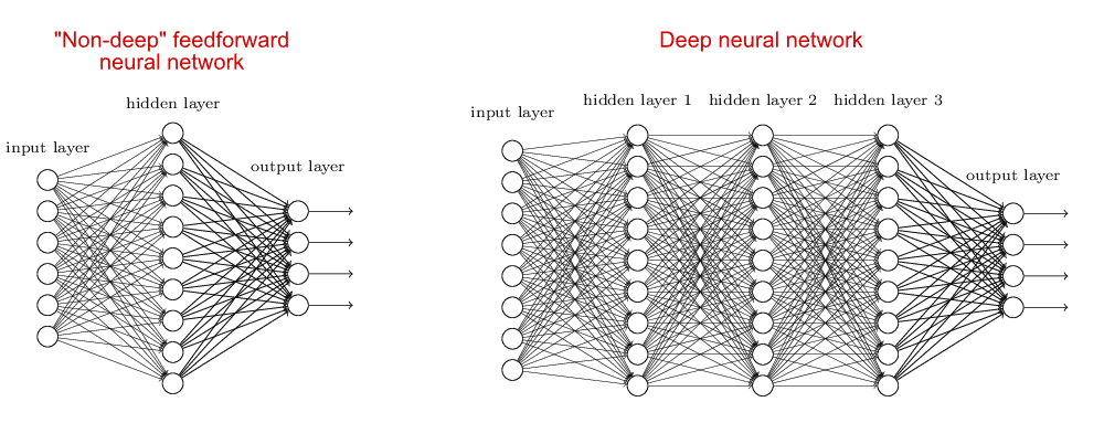
The evolution of data analysis from Machine Learning to Deep Learning has been possible mainly thanks to the expansion of the following developments:
- Big Data: with the democratization of the Internet, the proliferation of the Internet of Things (IoT), such as the implementation of sensors, and the exponential increase in satellites taking images daily worldwide, we currently have an enormous amount of data.
- Computational Capacity: due to the development of the cloud and Graphics Processing Units (GPUs), which allow parallel processing of thousands of tasks quickly and economically, computational resources are enormous.
- Algorithm Improvements: in response to some of the most pressing needs regarding the training of deep neural networks, researchers have managed to improve algorithms and network architectures. As a result, the obtained results improve rapidly compared to simpler algorithms.
Convolutional neural networks allow for easy image classification.
A type of neural network, Convolutional Neural Networks (CNN), allows for very efficient image analysis, evaluating groups of pixels and finding patterns, which will be associated with the corresponding label. Once the algorithm has been trained with a sufficient quantity of images, the Deep Learning model will be ready to face new images that have not been previously classified, which offers us a very powerful tool for obtaining information from our data quickly and easily.
Deep Learning Applications in Geographic Analysis
A discipline of Artificial Intelligence where Deep Learning has excelled is in the field of computer vision or the ability of computers to “see.”
The great speed at which drone, aerial, or satellite images are generated makes their classification and analysis to obtain results impossible through analog methods.
At LISDATA, we develop all the necessary processes for an exhaustive data analysis and devise tailored proposals through an optimal combination of your data sources and technologies for the processing and visualization of geographic information, detection and classification of objects, features, and events.
As applications oriented to the Inmologistics sector, satellite image analysis in combination with Deep Learning techniques and advanced analytics to integrate other complementary data sources (digital cartography, property registry, cadastre, etc.) enable:
- Automatic identification of available plots.
- Detecting changes in a property or modifications to a plot, perimeter, or access points.
- Identifying the characteristics of a property by identifying relevant assets such as buildings, swimming pools, parking, fences, sheds, surface sizes, shapes, etc.
- Assessing damages caused by natural disasters or human actions.
Use Case in the Inmologistics Sector: Identification of Warehouse Areas
Given the need of an international logistics operator to locate the best locations and facilities to acquire warehouses near mass distribution areas, LISDATA developed a search solution using satellite images related to cadastral data for the identification of plots and buildings classified by purchase potential.
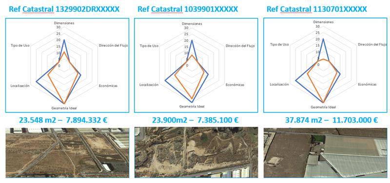
By means of algorithms for measuring the squareness of plots and warehouses and the analysis of satellite images and cadastral information, they were categorized according to size, geometry, symmetry, location, and price per m2.